India daily weather forecast latest March 30 Wet weather continues over Ladakh Jammu Kashmir Himachal Kerala and Northeast India
Northeast India could witness increasing rain from early on Tuesday with intensifying southwesterly winds
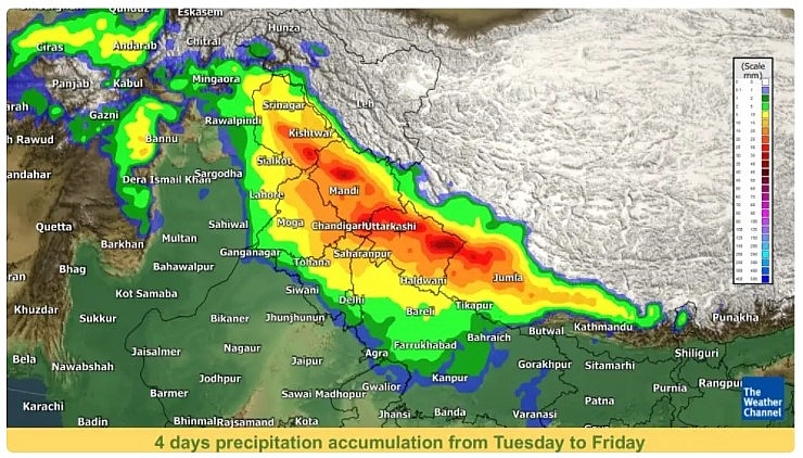
India is forecasted to cope with the presence of a western disturbance, which brings isolated to fairly widespread snow or rain over north India and adjoining areas from Tuesday to Friday.
According to Skymet Weather, a trough is extending from the southeastern parts of the Arabian Sea near-coastal parts of Kerala to Marathwada through coastal Karnataka and south-central Maharashtra.
A fresh Western Disturbance has reached North Pakistan and adjoining Jammu and Kashmir. Another western disturbance is seen over northern Afghanistan.
During the next 24 hours, there is a possibility of light rain and snowfall in the upper reaches of Jammu and Kashmir, Gilgit Baltistan, Muzaffarabad and Himachal Pradesh.
Light rains are expected over coastal Andhra Pradesh, southern Tamil Nadu and Kerala as well as Andaman and Nicobar Islands and parts of Lakshadweep.
Cold conditions are expected to continue over parts of Punjab, Haryana, Rajasthan, Madhya Pradesh, Uttar Pradesh and Bihar. Thereafter, the weather will change and there will be a rise in minimum temperature.
In the eastern parts of Uttar Pradesh and Bihar, dense fog is expected to continue for the next 24 to 48 hours.
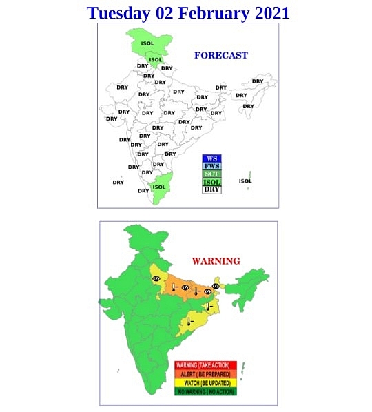
With the arrival of the second western disturbance, Delhi is likely to receive light rainfall between Wednesday, February 3 to Friday, February 5. According to the India Meteorological Department (IMD), isolated to fairly widespread rains and thundershowers with light to moderate intensity are very likely across northwestern plains from Wednesday to Friday.
Over northwestern plains, thunderstorms, lightning and hail could also accompany the unseasonal rains. Accordingly, Delhi, Punjab, Harayana and West Uttar Pradesh have been kept under an orange alert to ‘be prepared’ for adverse weather conditions for Thursday, February 4.
Moreover, scattered rain or snow with isolated thunderstorms is forecast over the Western Himalayan Region from Wednesday to Friday. Jammu and Kashmir, Ladakh, Himachal Pradesh and Uttarakhand have all been kept under an orange alert for Thursday. The rains are likely to extend up to central and eastern India also during the latter half of next week.
Western disturbances typically originate as low-pressure systems over the Mediterranean Sea. High-altitude westerly winds push these systems towards India. On the way, the disturbances gather moisture from various sources including Mediterranean, Caspian, and sometimes even the Arabian Sea. The influence of WDs is maximum over north India during the winter season from December to February.
According to Weather.com, parts of north India are expected to start the month on wet not due to the presence of a western disturbance. The system is likely to bring light snow or rain over north India on Monday. The system could also bring isolated to fairly widespread snow or rain over north India and adjoining areas from Tuesday to Friday.
Four days total precipitation of 30 mm is possible over Western Himalayan Region from Tuesday to Friday.
As per the India Meteorological Department (IMD), dry northwesterly winds over plains of north India and adjoining parts of central India are likely to prevail during the next 2-3 days. Under its influence, cold wave to severe cold wave conditions are expected over some pockets of Bihar, Gangetic West Bengal and Odisha during next the 2 days. Likewise, similar conditions will persist over Punjab, Haryana, Chandigarh, Delhi, Uttar Pradesh, Madhya Pradesh, Jharkhand, Sub-Himalayan West Bengal & Sikkim and Chhattisgarh during the next 24 hours and decrease in spatial distribution and intensity thereafter.
Cold day to severe cold day conditions are likely in isolated to some pockets of Uttar Pradesh, Bihar, Sub-Himalayan West Bengal and Sikkim during the next 24 hours. Moreover, dense to very dense fog is possible over Uttar Pradesh, Bihar and Sub-Himalayan West Bengal and Sikkim during the next 2 days.
Low-temperature conditions are likely over central India and northeast India in this period and over northwest India from Thursday onward. The low-temperature tendency is forecast to ease over central India and northeast India from Wednesday onward.
Maximum temperatures are 2°C to 4°C less than below average over north-central India, northeast India from Monday to Wednesday and over plain areas of north India and adjoining areas from Thursday onward. Minimum temperatures are lower below average over central India and northeast India from Monday to Wednesday.
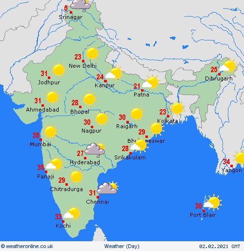
Meanwhile, in south India, isolated rain is likely over Tamil Nadu on Monday and Tuesday and over Andaman & Nicobar Islands in this forecast period. Dry weather is expected over other areas in this forecast period.
Isolated rain/snow is possible over Jammu & Kashmir, Ladakh and Himachal Pradesh. Isolated rain is expected over Tamil Nadu and Andaman & Nicobar Islands.
Dense to very dense fog is likely over isolated pockets of Uttar Pradesh. Dense fog is predicted over isolated pockets of Bihar and Sikkim.
Cold day conditions are likely over some pockets of Bihar and East Uttar Pradesh. Cold Wave conditions are expected over isolated pockets of Bihar, West Bengal and Odisha.
Ruby Lee