Singapore says almost 80% of population to be fully vaccinated by Sept
Almost 80% of Singapore's population will be fully vaccinated against COVID-19 by early September, the city
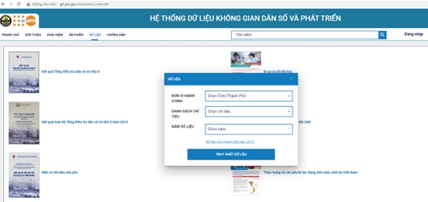
NDO/VNA – With the support of the United Nations Population Fund (UNFPA), the General Statistics Office (GSO) has developed a spatial population and development data webpage, at https://gis.gso.gov.vn, to utilise results of the 2019 Population and Housing Census.
A workshop was held on December 9 to announce the geographic information systems on population and development.
The webpage, the first of its kind in Vietnam, covers certain population and socio-economic indicators from the Census and other relevant sources to meet the needs of population research by geography.
The results of the Census are a reliable data source on population size at the commune level, as well as population and housing information by demographic and other characteristics in all 63 provinces of Vietnam.
Naomi Kitahara, UNFPA Representative in Vietnam, said the webpage has provided the latest information to serve decision making, calling for timely legal frameworks and policies that match rules of the International Conference on Population and Development (ICPD).
The data page was built with technical and financial assistance from the UNFPA Country Office in Vietnam, and with contributions from the UN Joint Sustainable Development Goals Fund.
It was developed based on the geographical coordinates of households and relevant population and socio-economic information for the period 2016-2020. Indicators were disaggregated by demographic characteristics and administrative units which will be annually updated. This will provide policy makers and researchers with important information about population and their geographical locations in relation to social and environmental issues, contributing to meeting research needs and evidence based policy development.
Logging in to the population and development spatial data webpage, users can observe the information represented by different map layers, from which they can extract data in excel files and graphs to support in-depth research and analysis.
The data page is also connected to the Disaster Monitoring System of the Ministry of Agriculture and Rural Development (Vietnam Disaster Management Authority - VDMA) and integrated with the spatial data of health facilities, which could be used to develop necessary interventions, focusing on vulnerable population groups such as the elderly, women in reproductive age and people affected by disasters.


